Showing posts with label Dams. Show all posts

Sunday, March 17, 2013

Chankapur Dam, Maharashtra.


The only information we had about Chankapur Dam in Nashik District of Maharashtra is that it does exist. And yet we reached there pretty much without getting lost. All thanks to smartphones and GPS apps. Chankapur Dam is about 40-odd kms from Saputara.

The idea was to reach Chankapur Dam a little after noon and then probably take a bath in the water and head back Surat. And we pretty much stuck to the plan except the bathing part. Upon arriving at the landing point closest to the water (as far as the GPS shows), we found the water to be too muddy for a bath. So shed our plans of taking a bath and instead relax a bit before heading back. Thankfully, there was a tiny shack built to take refuge from the beaming Sun. Even though there was no name scribbled on this gift-wrapped gift, I’m ready to believe it was sent from God. After all, here we were in the harshest of summers sitting on the banks of river Girna, nestled between a hill on one side and an idyllic village on the other and staring at a 41m high dam in the distance.

The Sun was so harsh that none of dared to put even a finger out of the shade while resting in the shack. We spent about an hour resting and having conversations on topics ranging from food, travel, cricket et al. As the conversation steered towards their college days, my own mind wandered into the horizon. And how I managed a cat nap I don’t know, but it was one of the best I’ve ever had. And then it was time to head back to Saputara, where we had a unusually heavy lunch before starting on the return leg of our bike ride to Surat. On the whole it was one of the best rides I’ve ever had. And definitely the longest in a day. We had covered close to 450 kms in a day.

Getting-there: From Saputara cross the border and enter Maharashtra. After some 5 kms on the highway there’s a left deviation to Chankapur road.

Must-Do: It’s best to carry a GPS app with you, or simply rely of directions from people.
Must-Don’t: Avoid coming in the summer.

My Rating: 5/10

Wednesday, December 26, 2012

Karapuzha Dam, Wayanad

Returning from Edakkal Caves we realised we were not left with much options for the remainder of the day. Meenmutty Falls was our original plan but conflicting reports of it being closed for tourists and the fact that we may miss the deadline for entry into the area made us fall back on Plan B. We zeroed-in on Karapuzha Dam as that was the closest to our accomodation in Meenangadi. Plus, we wanted enough time to relax before a demanding Day2 of our Wayanad trip.

Karapuzha Dam is built on the Karapuzha Lake, which is however a conglomerate of a dozen lakes. This place is not very touristy, but if you have an evening to kill and watch the sunset in Wayanad, then this is the place for it. This place also promises to be a good one for birding but I guess our timing wasn't right. The dam in itself is a very quiet place and unlike other dams across the country, this one is open to public and hardly has any security personnel around it.

After waking around the dam for a while and waiting for the sun to set, SM and I (who had driven the car last night taking turns) found a comfortable spot to lie down on. And before we knew it, we drifted into a deep sleep. And when I finally woke up i found, much to my dismay, the sun had set! But from what I heard from my co-travelers, the sunset was magical.


Getting: there: 17kms from Kalpetta and 6kms from Meenangadi.

Must-Do: Watch the sunset
Must-Don't: Littering

My Rating: 5/10

Thursday, April 19, 2012

Upper Bhavani, Ooty

Much like the previous evening, most of our day 2 morning was spent trying to figure out where we could next go. After getting turned down from officials from a couple of places we headed towards Upper Bhavani. Upper Bhavani is a dam built over the Bhavani Lake. It is located apparently at 7470 feet above MSL. The 20+km ride from Avalanche/Emerald Lake to Upper Bhavani took much longer than usual. I'm more than sure we lost our way somewhere and took a roundabout route. My co-travelers though refuse to buy that theory. Instead of the 20kms I'm pretty sure we travelled at least 40kms. The argument is still unresolved.
So, after much travelling we reached the gates of Tamil Nadu Electricity Board owned Upper Bhavani Dam. After paying Rs.50 to a drunken policeman a.k.a guard we gained access to the Dam premises. With paucity of time we had no choice but to rush to the dam, absorb the sights and head back. I can bet that on a different day of a different season, Upper Bhavani will offer breathtaking views. But this was not the day. With nothing much to do and not wanting to get caught in the wrong side of the Bandipur forests before the gate closes for the night, we headed back to Ooty and subsequently to Bangalore. Thus ended another semi-disappointing Ooty trip.

Getting-there: Upper Bhavani is 60 kms from Ooty.

Must-Do: Ogle at the green sea of tea gardens.
Must-Don't: Visit during summer

My Rating: 4/10

Emerald Lake, Ooty

With Pykara Lake and Glenmorgan done and dusted with, it was time to make our beds for the night. Hotel accommodation was something we have not even considered as a Plan B. The primary purpose of this trip was to camp in the wilderness of Ooty. But this task seemed harder to implement than thought. Apparently, one needed to obtain permission from the Forest Department to camp in the wilderness. And whomever we asked we were told that no permissions were given to camp near the lakes for fear of wild animals et al.

With a thin ray of hope we approached the Forest officials to obtain permission. But being a long weekend and the lateness in the hour we could contact anyone for the permissions. This was followed by more questioning of the local store owners and hawkers for a safe place to set our camp near any of the lakes for the night. With light and hope fading fast, we had to take a call. We finally decided to go to Lake Emerald and see if we can set a camp without or without permissions. If that was not to be, then we will settle for hotel accommodation somewhere in the area.

And it came to be that we arrived at Emerald in pitch darkness. Except for a bungalow next to the lake, there was no sign of humanity in the immediate vicinity. But before pitching our tent here, we needed to be sure that we will not have any trouble with the authorities or the wild animals. So we asked the people who lived in the bungalow and a few more people further ahead in the next village. Upon enquiry we were told that this place is neither frequented by wild animals nor will there be any objections in setting up a camp here. Armed with this info we pitched our tents here. We were in the process of starting a fire when we heard a man raising a battle-cry from the other end of the lake. He also started using his torch light in our direction whenever we used ours. First we ignored, but his insistenance got a few of us worked up. We weren't sure who or what it was all about. One thing we knew for sure that we did not want to give up this vantage camping point. So if the mystery man was a Forest Official who was trying to shoo us away, then that’s a risk we did not wish to take. To compound our problems a little while later we heard a loud sound, something like a gunshot. Now this really shook us up. The mystery man just turned into a frightening man. Was it really a gunshot we heard? Or do we really want to confirm it was a gunshot? We decided against any adventure and just call it a night sans the campfire and dinner.

I had a rather sleepless night thanks to reverberating gunshot sound and the merciless cold of the Ooty night. At 3AM I abandoned all efforts to catch a decent sleep and slipped out of the tent. To my delight I found that KB was having a similar night as I. We decided to make things right by starting a fire. At 3AM we were sure the mystery man would be fast asleep. But to our horror the moment we got our fire started, the yelling started. Not wanting to risk hearing another gunshot or similar sound we put out the fire and went in search of a different location to start the fire - away from the watchful eyes of our mystery man. We found a comfortable location and started the fire. It was a herculean task to start a fire considering that all the twigs and leaves we collected were dripping wet with the moisture of the early morning. But we persevered and soon we mastered the art of fire making against all odds.

The growling sounds of the stomach called our attention to have food. Since we had all the material resources to cook soup, the two of us worked in that direction and pretty soon we were sipping a hot cuppa soup with the sun rising in the horizon. It was a scene unlike I had ever witnessed in Ooty or any other location. This was the high point of my two trips to Ooty. And probably the "best" memory I will carry in my heart for the years to come.

After the sun was out in its full glory we finally figured out our Mystery man. The man across the lake was just a farmer, who was protecting his farm from possible intruders. So much for all the worries and the sleepless night we went through. But then, the mystery of the gunshot still remains a mystery.....


Getting-there: Emerald and Avalanche Dam is where you should be headed to reach Emerald lake.

Must-Do: Enquire for permissions to camp for the night. Tents, Sleeping bags, Lighter, newspapers and bullet-proof vest  will come in handy.
Must-Don’t: Littering

My Rating: 7/10

Monday, November 09, 2009

Savanadurga, Bangalore.

It had been almost a month since I hit the road and I was beginning to develop an itchy feet. Bad health and family commitments had kept me off road all this while. So the first chance I got, I was away. I announced to my partners-in-crime that this weekend was a biking and trekking getaway. 60 kms of biking and 4050 ft of vertical trekking. The Destination – Savanadurga. As I stepped out of the house at 6 in the morning and saw the steady drizzle coming down, I thought about all the blogs I read by those who have vanquished this mighty giant of a hill. Every blog I read warned of the danger surrounding the terrain during the rains. Now looking at the drizzle I must say I was elated. Yes, you heard me. Elated. I mean, what fun is an adventure without some danger!

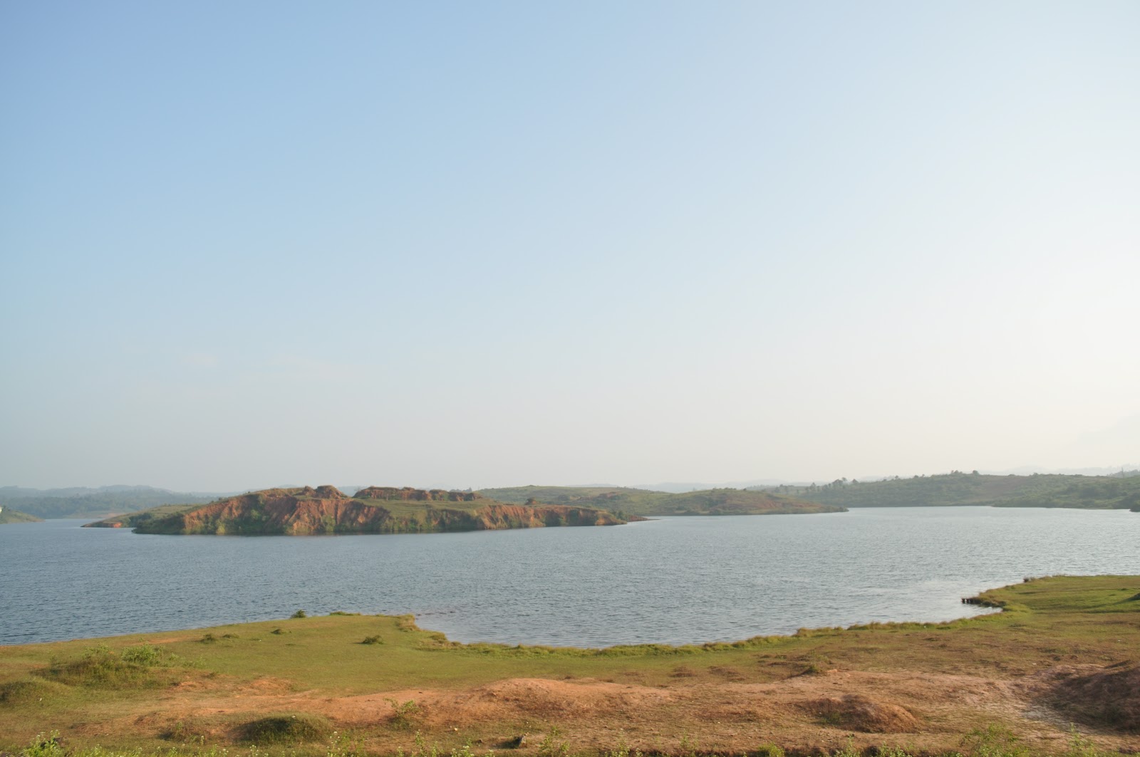
The Savanadurga is 14 kms from the Manchanbele Dam. There are two routes to reach Savanadurga. The first and fastest being taking the Magadi Road. The second and highly recommended is the Dodda Alada Mara-Manchanbele Dam route. I recommend the later because the 14 km stretch road leading from MD to Savanadurga is simply exhilarating. No, Im not talking about the quality of the road, but the beauty of the surroundings. Immediately after the dam is a village and after that you enter a forest reserve. The drive through the forest makes the slow-paced and time-consuming drive worth its weight in gold. After entering the reserve I could not but take my helmet away to breathe-in the fresh air. It’s a totally invigorating experience. Not for miles and miles away from Bangalore can one breathe such fresh air. It sure can rejuvenate your body to no end.

One more reason why you need to take this route is the umpteen number of hamlets you will cross. These are places where time stood still. It also brings back memories from my own childhood - memories of the humble village I’ve come from. Inhabitants here stare at you, like you’ve come from outer space.

The final 4km stretch – where all you do is circumvent the hills - to the foot of Savanadurga is a biker’s nightmare. Back-breaking is an understatement in this road - or what is left of it.

Just before you reach the foot hills you go past an ancient Nandi Temple (yes, there has to be a temple wherever you go). Outside this temple you will find an equally ancient Stumba and next to it, what looks like a giant swing with two mighty heavy iron chain hanging from the top. Also on the ground next to this giant-swing-like thing you’d find two mighty perfectly-circular boulders with a hole in the centre. Personally I have no clue what this is all about. A few more meters further and you reach ground-zero, where you’ll find a temple…again.

It’s always a good idea to have some coconut water before the long and demanding climb. Keeping yourself hydrated is the key. Traveling light is also a good idea, so we finished whatever water we had and threw away the bottle.

Wikipedia Corner:

Savandurga is a hill 33 km west of Bangalore off the Magadi road. The hill is famous for a temple and is also believed to be among the largest monolith hills in the world. The hill rises to 1226 m above mean sea level and forms a part of the Deccan plateau. It consists of peninsular gneiss, granites, basic dykes and laterites. The Arkavathi river passes nearby through the Thippagondanahalli reservoir and on towards Manchanabele dam. Savandurga is formed by two hills known locally as Karigudda (black hill) and Biligudda (white hill).

The climb to the top not surprisingly is tedious. No amount of yoga or umpteen hours on the treadmill will make the climb a cakewalk. While you are huffing and puffing your way up this monster of a hill, remind yourself to enjoy the breathtakingly scenic view. The silver lining is the Akravathi river winding its way down to the Manchanbele Dam. You could also get a good look at the ISRO Satellite Dishes situated near the dam. Further behind the ISRO you also see the concrete jungle that Bangalore is.

Barely a few feet away from the top of the hill and it started raining. But we were not in the mood to quit the mission after having come this far. Hence we quickly rushed to the top (the final stretch being the most difficult), took a few seconds to catch our breath, one last look at the scenic beauty laid before our eyes and we started our way. Almost immediately we realized the danger all those bloggers were talking about. Yes, it’s very real and very imminent. The slippery wet surface of the hill brought back memories of the day I decided to do a little bit of ice-skating. This is the best time to tell you that, Savanadurga is one real large, bald rock. It’s so bald it can put Pritish Nandy to shame!

We crawled, slipped, slid, skated, fell and sometimes walked our way to the foot of the hill. Getting down the hill was one of the most exhilarating episodes of my life. And it will remain etched in my mind for a long time to come.

Getting-there: Mysore Road -> Left at Raja Rajeshwari Dental College -> Big Banyan Tree -> ISRO -> Manchanbele Dam -> Right at village immediately after the Dam -> Through the Forest -> Right at the T-Junction Main Road.

Must-Do:
  • Keep yourself hydrated. Carry a backpack for carrying water and other liquids. Otherwise, there are boys who sell juice at the top of the hill – for DOUBLE the MRP.
  • The bag pack will also help in carrying your trash, there-by not littering the place.
  • Get your Trekking shoes on – preferably those by Woodland!
  • Breathe the fresh air of the forest.

Must-Don’t: Carry things other than a bag pack. You need two free hands along with your legs for the climb.

Road report:

  • Mysore Road – Paradise in the city.
  • Raja Rajeswari Dental College to ISRO – Good
  • ISRO to Manchanbele Dam – Bad.
  • Manchanbele to Main Road connecting the Hills – Drivable but narrow.
  • Final 4km stretch to the foot of the Hills – Nightmare!

My Rating: 7/10

Wednesday, October 07, 2009

Kanva Reservoir, Bangalore.

If you are planning to spend a coupla hrs of your lazy Sunday morning on a short long-drive in order to get away from mad concrete jungle of Bangalore and visit a place that is by no standards spectacular, then Kanva Reservoir is the place to be.

Let me reiterate that Kanva Reservoir on the river Kanva, which is a tributary of River Cauvery, is in no way spectacular. So visit this place only if you are running out of options to get away from Bangalore.

The most convenient aspect of visiting Kanva is its proximity to Bangalore and good Mysore Road, which makes the journey worthwhile. Getting to Kanva is pretty simple. Hit the Mysore Road and after crossing Ramnagara, there's the hard-to-miss Kamat Lokaruchi. A kilometer further to the Lokaruchi you need to take a right turn at the gap in the median. 8 kms of half-baked straight road will leave you at Kanva Reservoir. Kanva is a very quiet place, with hardly any visitors. Even the odd Qualis or Tavera that pulls in here, leave in a hurry. Not surprisingly there are no road side make-shift vendors too over here. No wonder the surroundings look a little neater compared to other destinations. Kanva, is one of the only destinations ive been to, where even the monkeys are surprisingly non-existent. Hmm..
The downside about Kanva is the fact that there's nothing you can really do over here. Especially if you belong to the group of people who don't want to get wet while on a long drive. So we just looked around for a spot to sit on and then started shooting pictures all over creation. Tired of clicking pictures we headed back to Bangalore after spending three quarters of hour here.

Oh... I almost forgot.. there's a Purushotthama Thirtha Gavi Cave Temple 3 kms further to Kanva if anybody is interested. Since we were not really the temple-going-types, we decided to give it a skip.
Getting-there: Mysore Road till Kamat Lokaruchi(60 kms) -> another 1km and then right at gap in the median ->9 kms straight road to Kanva.
Must-Do: Eat at Kamat Lokaruchi. Good Food. Check out Janapada Loka.
Must-Dont: Littering. Thankfully the influx of tourists is less and hence its pretty much litter-free. So lets keep it that way.

My Rating: 4/10

Monday, August 03, 2009

Manchinbele Dam and Dodda Alada Mara, Bangalore

Come Sunday and I had to hit the road. We were looking for the closest getaway from Bangalore and so zeroed in on Manchinbele Dam and Dodda Alada Mara. The Big Banyan Tree is a mere 30 kms from Bangalore and Manchinbele Dam another 10 kms further.
We started right by starting early. 6 AM sounded good on the blueprint. While execution though, we found it could have been a little more earlier. There was already a fair bit of traffic by then. The four of us in two different bikes converged at Corporation Circle around 6:15 and then hit the Mysore Road. Good roads - except for a 2 kms stretch (which will be mentioned later) - need a special mention for this trip. The route is pretty straight-forward. Some 15 odd kms on Mysore Road, you would arrive at Sri Rajarajeshwari Dental College Signal. You cannot miss this unless you are flying over!!! Take a right at this signal and follow the road. Taking no diversions, we reached Dodda Alada Mara in pretty good time. But we did not stop here. We wanted to get to the Manchinbele Dam, before the Sun hastens a forced retreat, back to the comfort of our homes. This also turned out to be a wise decision. We are getting good at this travelling stuff ;-)

The route to the Dam from here does not involve rocket science. Talking about rocket science, you could consider the ISRO station here as landmark on the way to the dam. This is where the road takes a low-down. The well-laid roads finally give way to typical village roads. This red-sand-and-concrete-stones road thankfully extend to only about 2-3 kms. From then on till Ground Zero its back to good roads. We were just limbering around driving at a sinfully slow pace soaking the beautiful village atmosphere when the breathtaking sight of the Akravathi river hit us like a bolt from the blue. The Akravathi looked comfortably cuddled between the mountains. Once you reach this place you'll find a forked road. The one on the left leads to the Dam while the other to the right follows a long winding road to the banks of the river. The right looked more exciting and we took it. The road downhill is bad, which makes it a little more adventurous. Driving slowly here, serves two purpose - keeping your head in place from falling off and enjoying the sights and sounds(or the lack of it) of the place. The serenity of the place is in stark contrast to the noisy nuisance of Bangalore. To our surprise we even found a BMTC bus (227A or something like that) drive past us, leaving a storm of dust behind it.

After spending close to an hour at the banks of the Akravathi, we decided to hike the mountain. But rough terrain, slippery rocks and cribbing co-hikers brought the hike to an abrupt end. We decided to drive a little more, but not having found anything more interesting we decided to drive back. On the way back we sighted the Dam a good 5-6 kms away. Thats when we actually remembered that the actualy purpose of the visit was to see the dam and now we were leaving without seeing it. The Manchinbele Dam is a miniature one by any standards. It has only three gates to it and basically it serves as a drinking water reservoir for the neighbouring villages. Having seen enough, we decided to leave the place.

The next stop obviously was the Dodda Alada Mara.
Some quick facts about the Big Banyan Tree:
1. Its very old. About 400-500 years old.
2. Its Big. It covers about 4-5 acres.
3. Its infested with monkeys.
4. It has a temple in its premises. There's always a temple right!!!

Burnt corn, disgusting bhel puri and refreshing tender coconut water marked the end of yet another perfect bangalore getaway weekend.

Getting-there: Take the Mysore Road -> 3 Kms after Kangeri, take right at Sri Rajarajeshwari Dental College -> Dodda Alada Mara in Ramohalli Village -> Left at Chikkapa(or was it Chandrappa) Circle -> ISRO -> Manchinbelle Dam. Best to keep asking for directions though.
Must-Do: Spend lazy hours at the banks of the river. There's boating too for those interested. Take pictures of Dodda Alada Mara for been-there done-that sort of thing.
Must-Don't: Litter of course. The biggest contributor to the litter being alcoholic beverages.
Must-Carry: Ear plugs to protect your eardrums from the blaring noise of the temple loudspeaker.
Caution: Stray dogs getting under your wheels on the Mysore Highway. Monkeys snatching food.

My Rating: 5/10 (Collective Score)

Friday, June 26, 2009

Pazhassi Dam, Kannur


I should have taken my R&D on Pazhassi Dam a little more seriously. This place is strictly a picnic place. And a picnic is no fun with just two people, ain't it?
Well.. so there's this Pazhassi Dam over the Pazhassi River and threes a small park, some greenery, a curious stalker and that's about it.
But what makes the whole 37 kms travel from Kannur worthwhile is this one picture Ive taken of the greenery of this place. Its only when I got back to Bangalore and copied the picture onto my laptop did I truly see the beauty of the picture. Not surprisingly, it is now my desktop picture.

The up-side about this place is its Dead Silence. Nowhere in the whole wide world will you find a more calmer place. Its so quiet out here that you begin to wonder if you have gone deaf. From time to time, you need to make a make a sound to ensure that you are indeed not deaf.

On the down-side, you would have enough of the place after a while and wish to back to the more feel-good mad rush of the city.

But then, if you are in Kannur with enough time at your disposal you could stop by this place and experience what is called "deafening silence".

Getting-there: Take a bus from Kannur to Mattannur. And another one from there to the Dam(the frequency of which is one bus every 2 or 3 hrs).
Must-Do: Take Pictures.
Must-Don't: Visit here, if you are fighting against time and Littering of course.
Tips: Better to go in a group. Ideal place for Frisbees and cricket, find out the bus timings for the return journey.
Warning: The place doesnot have a proper washroom!!!
My Rating: 5/10